Report Your Level
Preface
This is a fairly meaty topic for a Flybyte article; consequently we've split it into two parts. If you've read this first section and want to go straight onto the next section, then click here, otherwise, read on below!.
Introduction
I am regularly involved in providing the required flight and theoretical knowledge refresher training prescribed by the CAA to pilots who have infringed. As such, I get to see many of the reasons why those pilots have found themselves in that predicament. So here’s a bit of a low-down on one topic that quite regularly crops up as a major contributing factor, namely the misunderstanding or mis-interpretation about how "high" an aircraft is and the multitude of references we have about its "level". After revisiting the details of this subject, let’s also take a look at managing the threats and errors within this area. Some of this might be construed as teaching grandparents to suck eggs. And for that, I make no apology because this subject really does need to go right back to basics. However, many of you may well find snippets of information that is either new or even contrary to your understanding – so read on. What are we going to cover?
- Height
- Altitude
- QFE
- QNH
- RPS
- SPS
- GNSS (GPS) Altitude
- GAGL
- Electronic Conspicuity Devices
- Airspace Level Definitions
- Threat and Error Management
Height and QFE
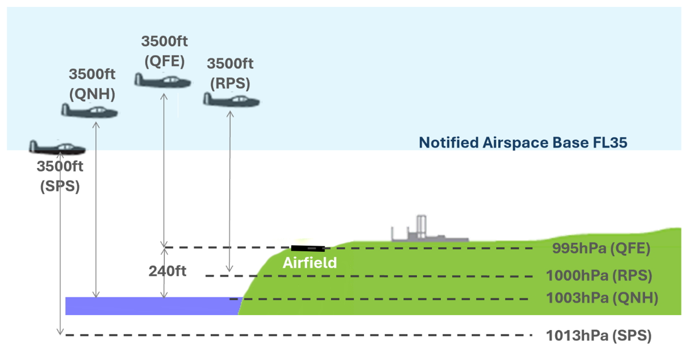
In the "good old days" pilots were solely interested in avoiding an infringement with the ground. When operating around an airfield (for example doing circuits), the primary pressure setting reference set on the altimeter would mean the altimeter read zero feet when the aircraft was on the ground at that airfield. That pressure reference is called "QFE", and the altimeter then indicates how high the aircraft is above the airfield. The correct Radio Telephony (RT) phraseology with the QFE set is to use the word "height" in transmissions, e.g. "G-ABCD is overhead at height 2000 feet".
Altitude and QNH
So now comes the problem of going from place to place when airborne. Things like terrain and obstacles have to be avoided when flying cross-country. Charts (you know, those paper things we used to carry around) need to show the pilot how "high" any terrain or obstacles are. So now we need a new reference to measure from, and that reference is Mean Sea Level (MSL). Since sea level is (relatively) consistent, the height of terrain and obstacles for the whole country are able to be stated above that singular reference. If atmospheric pressure at sea level is used as the altimeter reference, it will show how high we are in relation to sea level (and hence allow us to see if we are high enough not to collide with terrain or obstacles). This pressure reference is called "QNH". The correct RT phraseology with the QNH set is to use the word "altitude" in transmissions, e.g. "G-ABCD is overhead Ipswich at altitude 3000 feet".
The difficulty with QNH is that the atmospheric pressure at sea level will never be the same across a wide geographic area (let’s take the whole of the UK as an example). Because of the various high and low pressure weather systems the reference sea level pressure will change for different parts of the country. In other words, you can’t use the same QNH value for a flight from Lands End to John-O-Groats. If you did, you’d be in for a surprise during your travel; your altimeter would not be telling you the "truth" about your altitude in relation to the chart-stated altitudes of terrain and obstacles when you fly into an area with a different atmospheric pressure! To stop this from happening, it’s important to get the "Local QNH" for the area in which you are flying through, and this is usually obtained from a close-by Air Traffic Service Unit (ATSU).
But what about areas where there isn’t a close-by ATSU?
Altimeter Setting Regions and RPS
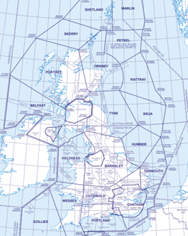
For this we need to refer to the UK Altimeter Setting Regions (ASR) contained in the UK AIP section ENR 1.7 and the ASR Chart in ENR 6-18. This shows that the UK is split into several geographic areas (regions) for which a reference (sea level) pressure setting is issued. This pressure setting is known as a Regional Pressure Setting (RPS). As a safety measure, the sea level reference pressure settings issued for each region is not an actual pressure setting, but the lowest forecast pressure setting due for the next 2 hours for any place within that region. This forecast pressure setting is updated every hour. Using the lowest forecast pressure setting means the aircraft will never be physically lower than the altitude indicated on the altimeter (but don’t forget the reverse is also true in that the aircraft will always be physically higher than the altitude shown on the altimeter).
It’s important to note here that some people call the RPS the "Regional QNH". That term should be avoided because although the pressure setting is indeed related to sea level, it is a forecast pressure setting and not an actual pressure setting, so the term QNH should not be used.
The aforementioned ASR’s really only apply to traffic in close proximity to terrain and ground obstacles; in other words the military or other national services that have a need to operate at those levels at relatively high speed with little time to obtain multiple local QNH settings.
Transition and SPS
Obviously, when we operate at higher levels, the proximity of terrain and obstacles becomes less important. It is more important for aircraft to be able to avoid each other by vertical separation – and for that, aircraft must operate on a common pressure reference. That common pressure reference is known as the Standard Pressure Setting (SPS).
In the UK the level where terrain and obstacles are generally not a threat is around 6000 feet, and this level is known as the "Transition Altitude" (details are in the UK AIP section 1.7). When an aircraft climbs above the transition altitude, the SPS can be set (1013hPa). The correct RT phraseology with the SPS set is to use the phrase "Flight Level" in transmissions, e.g. "G-ABCD Flight Level 60". Note that only the first 2 digits displayed on the altimeter is used, so 6000 feet equates to Flight Level 60. An altimeter showing 6500 feet would be transmitted as "Flight Level 65".
(For completeness here, when descending, there has to be a point where the pilot changes from SPS back to QNH since terrain and obstacles once again become a factor. The Flight Level at which that transition of altimeter pressure setting takes place is determined by ATSU’s and is called the "Transition Level").
GNSS (GPS) Altitude
Many (if not most) pilots now use a moving map device of some kind. It’s important to realise that these stand-alone devices have no connection in any way to the aircrafts altimetry system.
Where the device provides an "Altitude" indication, it is purely based on the altitude calculated by GNSS (GPS) triangulation. That calculation has inaccuracies due to the trigonometry (triangulation) used.
There is an additional complication though.
The reference used by GNSS (GPS) satellites for altitude is not exactly the same as the reference used by aviation which is Mean Sea Level (MSL).
MSL is based on a geoid model that represents the Earth’s mean sea level, which is an equipotential surface of the Earth’s gravity field and closely aligns with the actual shape of the Earth. This is the traditional, orthometric height or altitude that pilots and air traffic control use.
GNSS (GPS) satellites use an ellipsoidal model of the Earth as a reference which is a mathematical representation and differs from the geoid model that MSL is based on. The standard commonly used is called the WGS84 ellipsoid.
For practical purposes, especially in aviation, corrections are applied to GNSS (GPS) data (via Satellite Based Augmentation Systems (SBAS)Note 1 to convert the ellipsoidal height to a height above mean sea level, allowing for consistency and safety in flight operations.
SBAS also makes corrections for local variations in position errors obtained from the GNSS (GPS) system.
Note 1:
Satellite Based Augmentation System (SBAS) allows known inaccuracies in positioning information for the geographic area concerned to be re-transmitted via a geo-stationary satellite so that GNSS (GPS) receivers can apply the error correction to the normal GNSS (GPS) position data received.
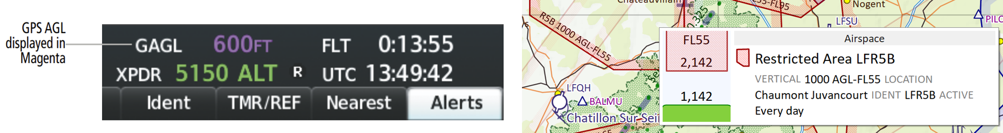
GAGL
This stands for GNSS (GPS) Above Ground Level and is a calculation of your GNSS (GPS) derived height above the ground beneath the aircraft.
Once again, the caveats in the previous section apply about accuracy and reliability. However, it’s a useful aid in negotiating certain types of airspace (particularly in France) that follow ground terrain. These are typically military danger or restricted areas with their vertical extents (both lower and/or upper) defined as "above ground level".
Electronic Conspicuity Devices
Electronic Conspicuity (EC) devices come in many shapes, sizes and abilities. One benefit of these devices is that the information received from an aircraft transmitting ADSB data will provide positional information which usually includes the vertical position component of that aircraft based on the SPS (1013hPa).
Where the EC device is connected to a moving map display, the difference in vertical position between your own aircraft and the target aircraft is usually displayed (as well as its relative lateral position) on the screen. For EC devices that are able to transmit ADSB information about your own aircraft, the altitude data (based on a pressure setting of 1013hPa) is derived from a stand-alone altitude encoder within the EC device itself.
... click here to continue to part 2 ...
|


© Copyright since 2016 Easy PPL Ground School.
All rights reserved worldwide.